|
|
Rancho San Francisco

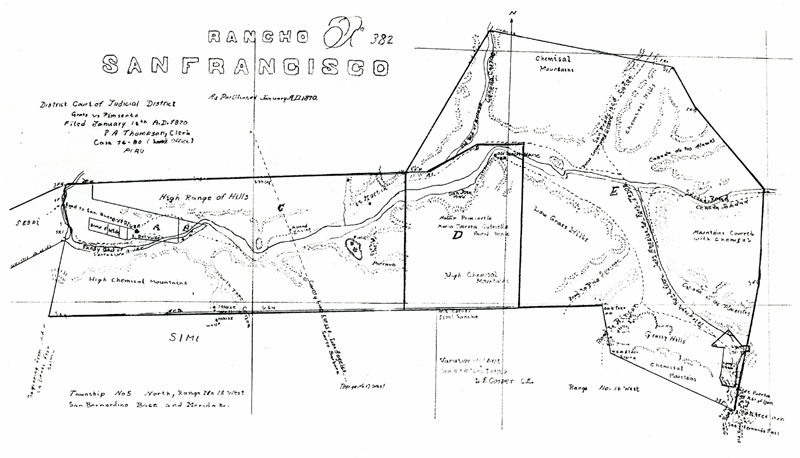
Click image to enlarge | Supersize Map of the partitioned Rancho San Francisco, January 13, 1870. Thomas Bard had acquired the Rancho San Francisco on March 18, 1865, after the drought of the early 1860s wiped out the Del Valle family's cattle herd and they couldn't repay their loans. Bard flipped the rancho a month later, on April 29, 1865, to Robert H. Gratz. According to this map, the survey came about as a result of a court case, Gratz vs. Pimsento. Meanwhile, the Del Valle family had retained ownership of the western edge of the rancho, the (then) 1,340-acre Rancho Camulos section. Four years after he acquired it, Gratz sold his interest on April 30, 1869, to the Philadelphia and California Petroleum Co., represented by Thomas Scott. According to Perkins, "Scott interests claimed an undivided 19/21 of the Rancho interests by purchase, having acquired all but those of Don Ygnacio del Valle, who continued placidly and profitably operating Camulos rancho, regardless of litigation, mining, petroleum, or the new ideas being brought into California life. The undivided 2/21 carried with it Camulos, legally, formally, and unencumbered. Its 1,340 acres were permanently separated and divorced from the troubled background of the grant." The map represents this partitioning of the rancho. For more about the partitioning, read Perkins. Note the demarcation between Los Angeles County and Santa Barbara County. There was no Ventura County until three years later, Jan. 1, 1873, when it split off from Santa Barbara County. Also note that the route of the Telegraph Stage line is shown running from Newhall Pass (which was not yet called that) up through San Francisquito Canyon.
HS7001: 19200 dpi jpeg. |
The site owner makes no assertions as to ownership of any original copyrights to digitized images. However, these images are intended for Personal or Research use only. Any other kind of use, including but not limited to commercial or scholarly publication in any medium or format, public exhibition, or use online or in a web site, may be subject to additional restrictions including but not limited to the copyrights held by parties other than the site owner. USERS ARE SOLELY RESPONSIBLE for determining the existence of such rights and for obtaining any permissions and/or paying associated fees necessary for the proposed use.


